
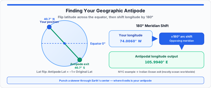
Childhood sandbox myths claim digging straight down reaches China. In my cartography experience, physical planetary math proves otherwise. Digging from North America actually drops you into deep oceans. Think of an antipode as your physical planetary twin. It is the exact spot upside down beneath your feet. Imagine punching a long skewer directly through an orange. The skewer exits on the exact opposite side immediately.
Geodetic mapping equations pinpoint this exit coordinate easily. Planetary symmetry dictates every single surface coordinate offset. Understanding these mathematical flips reveals fascinating geographic facts. Most people live directly opposite deep open ocean waters. You can verify your opposite coordinates instantly with our Antipode Calculator.
The Latitudinal Inversion Constant
Finding your exact latitude flip requires simple numerical inversion. Distance from the equator dictates your antipodal latitude value. Northern coordinates flip directly to matching southern coordinates. Southern coordinates invert straight to matching northern coordinates. When I plot coordinates on a global ellipsoid, sign changes suffice. Equator positions remain fixed on the central equatorial belt line. Forty degrees North becomes exactly forty degrees South. Polar coordinates invert between absolute geographic ends instantly. The North Pole maps directly to the South Pole. Geodetic ellipsoids maintain exact distance metrics during latitudinal flips. You can simulate your geographic inverse with our interactive Antipode Calculator.
Decimal Degree Mapping
Decimal degrees simplify raw latitudinal hemisphere sign inversions. Positive decimal values represent northern latitude points cleanly. Negative decimal values designate southern latitude locations explicitly. Multiply northern decimal values by negative one for inversion. This simple multiplication alters the hemisphere reference completely. Surveyors rely on decimal degrees for automated script calculations. To get started, reference basic latitudinal sign rules directly.
Hemispheric Sign Rules
Latitudinal calculations maintain exact angular distance from zero degrees. The equator line acts as the central reflection axis. Distance stays equal while hemisphere orientation reverses completely. A coordinate at ten degrees North flips to ten South. A coordinate at eighty degrees South flips to eighty North.
Antipode Latitude = −1 × Original Latitude
The Longitudinal Meridian Shift
Moving onto east-west shifts, simple sign flipping fails completely. Longitudes require an absolute one-hundred-eighty-degree rotational shift. Earth rotates around an active central rotational axis line. Opposing meridians sit halfway around the planetary circumference. In our geodetic mapping runs, meridian arcs split space evenly. Subtracting or adding 180 degrees locates the target meridian. Positive Eastern longitudes shift directly toward Western longitudes. Negative Western longitudes shift straight toward Eastern longitudes. Calculating meridian shifts completes the full antipodal coordinate pair. You can map out your exact planetary opposite using the Antipode Calculator.
Prime Meridian Arcs
The Prime Meridian serves as global longitude ground zero. Greenwich observatory anchors this central zero-degree reference line. Zero degrees longitude maps directly to the International Date Line. One hundred eighty degrees longitude marks the exact opposite arc. Every global longitude point possesses an opposing meridian arc. Moving east or west alters your relative meridian alignment.
Longitudinal Calculation Rules
Two mathematical steps solve every longitudinal shift calculation. If original longitude is positive, subtract one hundred eighty degrees. If original longitude is negative, add one hundred eighty degrees. In practical environments, this preserves valid coordinate range boundaries. Longitude values must always remain between negative and positive 180.
Antipode Longitude = Original Longitude − 180 (if Longitude > 0)
Antipode Longitude = Original Longitude + 180 (if Longitude < 0)
Example: New York City at 74.0060° W becomes 105.9940° E after the meridian shift. Confirm both steps in the Antipode Calculator or measure surface distance between any two points with the Latitude Longitude Distance Calculator.
The Global Oceanic Bias
Water covers over seventy percent of the planetary surface. Land masses do not align evenly across opposing hemispheres. Most land coordinates terminate directly inside deep ocean waters. North American locations almost exclusively exit into the Indian Ocean. European locations mostly exit into the South Pacific Ocean. Australian locations map straight into the North Atlantic Ocean. Only rare antipodal pairs link major continental urban centers. In my cartography experience, finding land exits remains rare. Geographic asymmetry places most human populations opposite empty sea.
True Antipodal City Pairs
Madrid in Spain maps almost perfectly to Weber in New Zealand. Xi’an in China exits directly near Santiago in Chile. Auckland in New Zealand aligns closely with Seville in Spain. Suhar in Oman connects straight to Easter Island in Chile. Ulan Ude in Russia drops into Puerto Natales in Chile. Bogota in Colombia exits directly inside Jakarta in Indonesia. Formosa in Argentina connects cleanly to Taipei in Taiwan.
| Major Global City | Original Coordinates | Antipodal Exit Coordinates | True Exit Surface Type |
|---|---|---|---|
| New York City, USA | 40.7128° N, 74.0060° W | 40.7128° S, 105.9940° E | Indian Ocean |
| London, United Kingdom | 51.5074° N, 0.1278° W | 51.5074° S, 179.8722° E | South Pacific Ocean |
| Tokyo, Japan | 35.6762° N, 139.6503° E | 35.6762° S, 40.3497° W | South Atlantic Ocean |
| Madrid, Spain | 40.4168° N, 3.7038° W | 40.4168° S, 176.2962° E | Weber, New Zealand (Land) |
| Beijing, China | 39.9042° N, 116.4074° E | 39.9042° S, 63.5926° W | Bahía Blanca, Argentina (Land) |
Open Antipode Calculator Open Lat/Long Distance Calculator
Frequently Asked Questions
Where do you land if you dig through the US?
Digging from the continental United States lands in the ocean. Most exit points sit inside the southern Indian Ocean. No continental US locations exit onto mainland Asian ground. Hawaii exits directly into central southern Africa ground space.
Are there major cities that are exact antipodes of each other?
Very few major urban areas form perfect antipodal pairs. Madrid in Spain and Weber in New Zealand form one pair. Beijing in China and Bahía Blanca in Argentina align closely. Taipei in Taiwan aligns cleanly with Formosa in Argentina.
How do you calculate antipodal coordinates manually?
Reverse the sign of your current latitude coordinate first. Add or subtract 180 degrees from your longitude coordinate. Verify that output values remain within standard coordinate limits.
Why do most land antipodes land in the ocean?
Oceans cover more than seventy percent of Earth’s surface. Northern hemisphere land mass vastly exceeds southern land mass. Geometric probability heavily favors oceanic exit locations worldwide.